 RF
RFGeodatabase: Advantages and Disadvantages in GIS
Advertisement
This article explores the pros and cons of using a Geodatabase, a crucial component in Geographic Information Systems (GIS).
What is a Geodatabase?
Introduction:
The ESRI® ArcGIS® applications (like ArcMap™, ArcCatalog™, and ArcToolbox™) utilize geodatabases alongside coverages and shapefiles. The term “geodatabase” is a combination of “geo” (referring to spatial data) and “database” (referring to a Relational Database Management System or RDBMS).
- It serves as the native data storage and data management framework for ArcGIS.
- It acts as an organizational tool for storing and managing data.
- It’s a gateway to advanced GIS capabilities.
Figure 1 illustrates geodatabases in GIS.
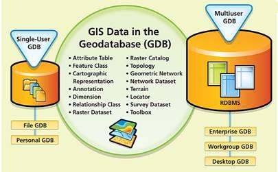
The geodatabase is a container holding various geographic datasets.
It supports diverse data types used by ArcGIS, including:
- Attribute data
- Geographic features
- Satellite and aerial images (raster data)
- CAD data
- Surface modeling or 3D data
- Utility and transportation network systems
- GPS coordinates
- Survey measurements
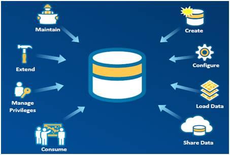
The figure depicts geodatabase life cycle.
A complete set of conversion tools is available to migrate existing geospatial data into a geodatabase. It can be scaled for single-user or multi-user access.
Fundamental ArcGIS datasets include tables, feature classes, and rasters. These, along with more complex datasets like topologies and geometric networks, are contained within the geodatabase.
There are three types of geodatabases: Personal geodatabases, File geodatabases, and ArcSDE geodatabases.
Benefits (Advantages) of Geodatabase
Here are some of the key benefits of using a Geodatabase:
- Centralized GIS Data Management: It offers centralized GIS data management by allowing multiple spatial and tabular data formats to be stored in the same geodatabase. This makes GIS data easier to manage and access.
- Handles Large Datasets: Geodatabases can accommodate large sets of features without the need for tiling or other spatial partitions.
- Supports Advanced Geometries: It supports two, three, and four-dimensional vector features (x, y, z, and m values), true curves, and complex polylines.
- Feature Classification: You can classify different kinds of features within a feature class by creating subtypes.
- Improved Data Editing: Validation rules can prevent many errors and identify others, leading to more accurate data editing.
- Custom Features: It’s possible to create custom point, line, and polygon features.
- Geometric Networks: You can model the flow of resources along a geometric network. This network combines line and point feature classes into a single database entity and maintains explicit topological relationships between the features.
- Multi-user Support: Multiuser geodatabases support versioning, allowing multiple users to edit the geodatabase simultaneously.
- Integrated Environment: Geodatabases support large data management in a continuous integrated environment viz. raster/vector/tabular/CAD (SDE).
- Graphical Modeling: Geodatabase schema can be graphically modeled using UML and later generated using CASE tools.
Drawbacks (Disadvantages) of Geodatabase
Let’s explore some of the disadvantages of Geodatabases, specifically focusing on personal and file geodatabases:
- Personal Geodatabases: These are subject to functional limitations:
- The database size is capped at two GB, with effective performance starting to decline between 250 and 500 MB.
- Supports only single-user editing and does not support versioning.
- File Geodatabases: Some disadvantages for preservation include:
- Closed Specification: Unlike Shapefiles, an open specification hasn’t been provided, limiting broad software support.
- Difficult Inspection: As a collection of binary files with an unknown structure, file geodatabases cannot be inspected as easily as a Personal Geodatabase (.mdb file).
- API Limitations: The file geodatabase API, released in June 2011, has documented limitations regarding various dataset types and most raster-related database components.
- Transfer Issues: The directory structure requires care during data transfer. Databases can be corrupted if not transferred correctly, or if files are renamed.
- Limited Metadata Accessibility: Metadata is not externally accessible without using Esri’s ArcCatalog software.
Advertisement


